

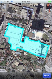
uScaleit+ produces area and linear measurement estimates for any location in the world, using Google Maps. A user types in a landmark, address or zip code and is presented with an aerial photograph of that location. The user then zooms and pans the image to a specific location and touches “Done” to lock the image in place. Touching points on the screen produces calculations. A stylus can be used for a more accurate placement of points. Shaking the device clears the screen so that another calculation can be made. The application has a switch that can be used to present calculations in English or metric units and it is available when the user touches the page curl icon. Area calculations are presented in square feet, square yards, acres, and square miles or in square meters and square kilometers. Distance calculations can be presented in feet, yards and miles, or meters and kilometers. This application let’s roofers, paving contractors, real estate agents, civil engineers, and land planners create area and linear measurement estimates while they are onsite. Estimates for rooftops, parking areas, bodies of water, property frontage, or shorelines can be generated. The application can produce calculations associated with disaster areas that use views of structures before the damage has occurred could.
How to use tips and tricks coming soon!